Category Archives: apps

5,953 Days Later: A Miracle Occurs. 8,859 Days to Go

September 11, 2001.  Terrorists attack the United States.  2,996 people died.  The economic damage was more than 250 billion dollars.  The 9/11 Commission Report made 46 major recommendations in 8 categories.  Virtually all the recommendations were implemented.

Except, perhaps, one.

On December 29, 2017, that is 5,953 days after the attacks, this recommendation finally was addressed:

Allocate more radio spectrum and improve connectivity for public safety communications, and encourage widespread adoption of newly developed standards for private-sector emergency preparedness—since the private sector controls 85 percent of the nation’s critical infrastructure.

firstnet-50

FirstNet’s States

On December 29, 2017, the First Responder Network Authority (FirstNet) became a reality in all 50 states, the District of Columbia and two United States Territories.   FirstNet was created by Congress on February 22, 2012.  Congress allocated 20-megahertz of radio spectrum for FirstNet’s use in creating a nationwide mobile wireless (cellular) network where first responders will have priority.  Congress stated FirstNet must use long-term-evoluation (LTE), a worldwide standard, for the network.  And, while many public safety responders work for governments, there are private sector first responders too, protecting critical infrastructure, who will have priority on the network.   AT&T won a competitive contract to deploy the network, and promised priority on all its existing LTE spectrum, as well as the 20-megahertz assigned to FirstNet.

AT&T delivered on that promise on September 30, 2017.  But the Governor of each State and Territory, and the Mayor of D.C., each had to decide whether to participate in this network.  On December 28, 2017, California became the 50th state, and 53rd government (including D.C., Puerto Rico and the U.S. Virgin Islands) to decide to participate in FirstNet.

PSAC-Atlanta-2017-group-photo3

Public Safety Officials

Thousands of Chiefs of fire-and-rescue, law enforcement, emergency medical services, and 9-1-1 centers advocated for FirstNet to happen.  Hundreds of federal, state and local officials worked on the details, and hundreds of AT&T employees brought it to fruition on the carrier’s existing infrastructure.

The vision of the 9/11 Commission is, at long last, 5,953 days later, realized:   a nationwide public safety communications network.

Still, there is much to be done.

New advances in technology and therefore terrorist, criminal and public safety capabilities are constantly occurring.  Hacking, cybersecurity, new smart phones, the Internet of Things, body-worn video cameras, new applications, unmanned airborne vehicles, natural language processing (Siri, Alexa, Cortana) and artificial intelligence are just a few of those advances.  Public safety agencies often lag in adopting these technologies to support their mission of keeping 320 million Americans safe.

While one of the last chapters of the 9/11 story is now closing, many new challenges and opportunities present themselves.

The contract for FirstNet has a 25 year life, starting March 30, 2017.  There are 8,859 days remaining.   Many challenges still remain to be completed:  public safety agency adoption of FirstNet, an applications store filled with innovative apps, the Internet of Life-Saving Things, cybersecurity, network connectivity in remote areas and more.

Nevertheless, our nation’s first responders now, on December 29, 2017, finally have a nationwide wireless network with priority for their smart phones, mobile data computers, tablets and other devices.

1 Comment

Filed under 911, apps, FirstNet, Uncategorized

The Internet of Speeding Parking Things

School Zone Speed Camera

School Zone Speed Camera in West Seattle

My spouse recently got a speeding ticket.  In the mail.  From the Seattle Police Department.  For 32 miles per hour in a 20 mile per hour zone.

Not just any zone.  A school zone.

On her way to work.  As a teacher.

234 bucks.

It was a ticket from one of those automated semi-robotic radar guns with a camera which shoots innocent citizens as we drive past schools so fast we’re like bowling balls racing toward the pins.  Well … perhaps … racing past the “kids”, as the case may be.

Now I have nothing against kids.  Gee, we’re raising two of them.  Six and ten years old.  The last thing I want to do is have them mowed down by racing middle-aged banshees trying to get to work.  But getting a ticket in the mail two weeks after you commit the offense is not exactly what I would call “preventative policing”:  protecting kids by slowing people down and giving them (the drivers, not the kids) immediate, on scene, in-your-face feedback that they are going too fast.

Don’t get me wrong.  A $234 speeding ticket got the attention of both my spouse and me.  For a few minutes.  Until the next time we are late to work.

Like most (generally) law-abiding citizens, we don’t want to speed.  Especially in school zones.  Or in places where there is an automatic semi-robotic radar gun with camera waiting for us.

Isn’t there a better way to protect kids and keep law-abiding citizens … Well … Law abiding?

Enter the Internet of Speeding and Parking Things (IoSPT).

arnold-terminator

Arnold the Terminator as voice for your new “Don’t Speed” App

Why don’t we attach a transponder (fancy word for “radio”) to every speed zone sign in a City?  Then let’s distribute – for free – an app to every citizen and to every automobile we own (yes, cars run apps too).   The speed sign talks to the app and the app talks to the smart phone (or to the car itself) and the phone screams at the driver “slow the hell down, dumbo, you are going too fast, and you are going to get a ticket.  A two-hundred and thirty-four dollar ticket.  And the judge is going to throw the book at you because you are driving like a pitcher’s fastball toward the umpire but aimed at a bunch of innocent kids in a school zone.  Get your frigging act together and step on the brake, dammit.”

Perhaps the app can have the voice of Arnold Schwarzen-what’s-his-name or Clint Eastwood.  “Slow down or you are going to Make the Mayor’s Day” (or at least help the Mayor close her budget gap).

While we are at it, how about putting IoSPT things in a lot of places in our roadways, not just speed-zone signs?  Like in every parking meter (do those even exist any more?) or embedded in curbs or guard rails.   Such devices could really help us law-abiding citizens stay law-abiding.

Example:   Warning us when our parking time is about to expire – and we could use our app to pay a premium to buy more time.

IoSPT devices in every parking space could visually map all the parking spaces available in a city, directing people to immediately available on-street parking rather than encouraging endless “circling the block” to find an open space.  THAT contributes to pollution and climate change.  (San Francisco actually is piloting this technology).

IoSPT things in traffic lights could alert cars and their drivers via an app to stop when the light turns red, and even prevent cars on the cross street from starting up too fast to hit the red-light runner (who would automagically get a $234 ticket, by the way).

fingernail-painting-driving

Painting Nails while Driving

IoSPT devices in guard rails and median strips and other roadway obstacles could help semi-automated cars stay in their lanes, or at least alert those of us who text or do email while driving (or paint our fingernails or do our hair while driving) that we are swerving out of our lane.

We talk to our smart phones all the time, with digital assistants like Siri and Cortana and Google Voice.   I suppose Amazon will even have “Echo for the Car” soon so the car can automatically order itself more oil or windshield wiper fluid when needed.

So why not have the road talk to the car?  And its driver?

I suppose some governments, taking a clue from George Orwell’s “Big Brother”, will force cars to slow down in school zones.  In other words, the speed sign talks to the car and tells the car it can’t go faster than 20 miles per hour.   And it doesn’t.

eckstein-drunk-driver-killer

Eckstein Middle School Zone after Drunk Driver kills Grandparents

But is that so bad?  Perhaps “Big Brother” cars will prevent tragedies like the multiple-time drunk driver who killed two grandparents and seriously injured a mother and her newborn at Seattle’s Eckstein Middle School in 2013.  And keep the rest of us on time for work because we are not going to get to speed through a school zone.  Period.   And perhaps let a few more innocent kids live to become speeding adults.

Oh sure, the IoSPT would put some people and things out of work.  Meter maids (I mean:  “parking enforcement officers”).   Automated semi-robotic radar guns with cameras.  Perhaps a few police officers.  But gee, don’t we have enough other crime and public safety problems that perhaps a few of those folks could be redeployed to address them?

Except the automated semi-robotic radar guns with cameras.

Those go to the junkyard.

3 Comments

Filed under apps, future of technology, government operations, Internet of Things

Lessons from NG-3-1-1 for NG-9-1-1

Next Generation 911When you are in a life-threatening emergency – a serious car accident or having a heart attack or your house is on fire – what do you do? You call 9-1-1, of course. With the emphasis on CALL, because, with just a few exceptions, there’s no other way to get police or firefighter or emergency medical help except calling on the phone. You can’t text 9-1-1 or send an email to a PSAP or tweet to 9-1-1.

9-1-1 Centers, often called PSAPs or Public Safety Answering Points, have a lot of sophisticated technology beyond 1920s-era voice phone calls, but very little of it is used to communicate with the public.

The National Emergency Number Association (NENA) and the government – specifically the Federal Department of Transportation – have a plan to fix that. The plan is called “Next Generation 9-1-1” or NG-9-1-1. At some point you may be able to text 9-1-1 or send an e-mail message or upload photos and video to help first responders protect life and property.

Some cities, however, have already implemented 3-1-1 systems for non-emergency customer service. In these cities – Portland and Denver for examples – you call 9-1-1 for emergencies and 3-1-1 to get help with any other municipal government service such as building permits, streetlight repair or animal control.

I recently did a podcast with Mark Fletcher on the Avaya Podcast Network (APN) discussing 9-1-1, 3-1-1 and these next-generation contact methods for the public. Fletch (@Fletch911) and I came up with the term “Next Generation 3-1-1” to describe using a set of new technologies and social media for citizens to reach their governments for service.

What can NG-9-1-1 and PSAPS learn from “next generation 3-1-1”?

Next Generation 311 - term coined in this blogWell, for one thing, “next generation 3-1-1” has already arrived. If you are in one of the places with 3-1-1, you can obviously just call that number to initiate almost any government service or report a problem. But virtually all those 3-1-1 cities also offer a 3-1-1 web input form and give you a tracking number. Some of them now tweet and allow tweeting as an input. Others are experimenting with Facebook pages, online chat, and email. Many of these contact methods allow you to send a photo or video of the issue.

Another common contact method is texting – there’s even “an app for that” in Textizen, developed by Code for America. In truth, Textizen is as much about citizen engagement and interaction as it is 3-1-1 and requesting service. But the important point is that Philadelphia, Austin, Salt Lake City and other places have implemented it as an alternate contact method.

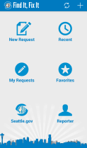
Seattle's Find-It Fix-ItA final, powerful, “NG3-1-1” technology is the downloadable mobile app. Some cities have developed their own app such as Boston’s Citizen Connect or Seattle’s Find It Fix It. These are sometimes built on technology developed by private companies such as Connected Bits or See-Click-Fix (Ben Berkowitz, the CEO, is a worldwide leader in this space).

A frequent criticism of NG-3-1-1 services and apps is that they only work in one city. You can download the “Chicago Works” NG-3-1-1 app, but cross into the suburbs and it is useless. But Boston and Massachusetts fixing this by extending Boston’s Citizens Connect into Massachusetts Commonwealth Connect. This allows 40 cities in Massachusetts to have their own individually branded app, but, using the GPS feature on smartphones, to report problems no matter where they are. A resident of Chelsea who is in Boston for a Red Sox game could see a problem – a smashed stop sign for example – and use the Chelsea app to report it to the Boston.

Admittedly, we have a long way to go with 3-1-1 – most places in the nation don’t have it (indeed, even in Boston and Seattle you don’t call 3-1-1, but rather a 10 digit phone number). But we can still think about some future “next generation” features for 3-1-1 which would be relatively easy to implement with today’s technology even if they are still difficult to implement in the culture of government operations:

  • Fedex-style tracking of service requests. With tracking you could snap a photo of graffiti, get a tracking number and then be notified as the service request is reviewed, triaged, sent to the police department for review by the gang unit, sent to “graffiti control central” to determine if it is on government property and which department (transportation, parks, etc.) is responsible to clean it up, see when the crew is dispatched, be notified when the work is done, and then be asked your opinion of how well the whole process worked. (Some 3-1-1 apps purport to do this now, e.g. Chicago, and the Open 3-1-1.org organization actually is evangelizing it).
  • 3-1-1 Open Data and analysis.  The details and results of 3-1-1 calls for service should be on an open dataset for anyone to review and, indeed, are in some cities such as Boston, New York City, and San Francisco. Certainly departments and Mayor’s Offices should be analyzing the tracking data to improve service management processes. But how about mashing the 3-1-1 data up against datasets such as building code violations, utility shutoff due to non-payment or crime incident reports to find “hot spots” of difficulties in the City which need to be broadly addressed by cross-functional teams from law enforcement, code enforcement, social workers and more. Boston is, indeed, doing this, but I’ve not been able to find detailed data about it.  (Note:  Socrata, headquartered in Seattle, is the software driving all the “open data” sites mentioned above as well as hundreds of others such as the Federal Governments own data.gov.
  • Facetime and Skype to 3-1-1, conveying video to the 3-1-1 operator so they can see your situation or you can show them graffiti, a problem in the street, and so forth.
  • Chat and video chat. Chat functions are fairly common on private customer service sites but extraordinarily rare in government. Indeed, I can’t cite a single example. I think government customer service departments are concerned about being overwhelmed by work if chat is opened to the public.
  • Twitter and Facebook comments/apps. Elected officials certainly realize the power of Twitter and Facebook. And I think they (or their staff) actually review and respond to comments or tweets, and even turn them into service requests for follow up. But most of the line departments in most cities (water, transportation, public works, certainly police and fire) don’t accept calls for service via these social media channels. I’d also like to see developers write Facebook apps or games which could be used inside that social media community to engage the public or manage 3-1-1/service requests.

Lessons for NG-9-1-1. I’ve laid out a long list of examples and suggestions above which, together, could be called the “landscape and roadmap” for Next Generation 3-1-1. Some of them clearly could be adopted for use in PSAPs and 9-1-1 centers. The “low hanging fruit” here, I think, for NG 9-1-1 is:

  • A smartphone app for texting 9-1-1. Although you can directly text 9-1-1 from your phone, an app would be better because it could prompt you for critical information such as your location. Textizen could be an NG-3-1-1 model for this.
  • A smartphone app for calling 9-1-1. This sort of app might not just telephone 9-1-1, but also allow you to include photos or other data from your phone, including GPS coordinates, direction and speed of travel etc.
  • Facetime or Skype to 9-1-1. Such an app (when PSAPs are able to receive the information) would allow the telecommunicator in the PSAP to see what’s happening to you or in your area.

A number of obstacles remain, however:

  • Technology is an obstacle, as most 9-1-1 centers don’t have even text messaging available, much less email, twitter or chat. A notable exception: York County, Virginia, where past APCO president Terry Hall directs the 9-1-1 center – you can text 9-1-1 in York County.
  • Culture and training are an obstacles. Telecommunicators (call takers and dispatchers) in 9-1-1 centers know their jobs extraordinarily well and execute them almost flawlessly, as you hear from tapes after any major incident. Every new technology or method of communication we add to the PSAP makes those jobs harder in terms of training and obtaining the right information to get first responders to the incident.
  • Chain of evidence. When a video or video call or image is sent from a citizen to a 9-1-1 center about a crime, can it be used as evidence? Has it been altered (even by Instagram) thereby perhaps rendering it useless in a court of law?
  • Security and cybersecurity. We’ve seen cases of “spoofing” telephone numbers and “swatting”, where 9-1-1 centers are tricked into sending officers or SWATs to unsuspecting citizens. Every new method of communicating adds new difficulties in verifying caller identities and preventing such antics.

And, most importantly, with 9-1-1 lives are often at stake, so thorough research and preparation must precede adoption of these new technologies in PSAPs.

My podcast with Mark Fletcher on the Avaya Podcast Network was a fortuitous meeting. We’ve probably coined the phrase “Next Generation 3-1-1”. But while the tools and technologies of NG-3-1-1 certainly chart a path for PSAPs and NG-9-1-1, following that path will require innovative solutions to a number of obstacles.

3 Comments

Filed under 311, 911, apps, future of technology, open data, social media

Apps Contests are Stupid

Hackathons and App ContestsIt seems like apps contests and apps challenges and hackathons sponsored by governments have been all the rage over the last couple of years.

They were kinda cool when they were new, in 2008, such as Washington DC’s original “Apps for Democracy“.   Vivek Kundra, then CTO of the District, valued the apps developed there at $2.3 million, although how he arrived at that number is unknown.

But now apps contests are not just overdone – there are just so many of them – but actually are becoming counterproductive, turning off developers and governments.   In fact, they are stupid.

Why?

First, the data sources are not standardized between different cities, counties and states.   This leads to myriad problems.

One of the great breakthrough ideas in the government of the District of Columbia in 2008 was the concept of a “data catalog“.   Governments have always had masses of data which they crunched to produce reports and insights and to support policy development.  But they also kept such data under lock-and-key.   The District’s government made some of those datasets open and available for citizens, academics, researchers and app developers to use.   Kundra’s successors in D.C., Bryan Sivak and Rob Mancini, extended the District’s data catalog to 507 datasets.   Kundra ported the idea to the federal government with data.gov, and a whole industry – including Seattle startup Socrata, is now built on opening up data.

But very few “normal” citizens are interested in this stuff.  Many of them don’t have the skills or interest to spend a lot of time loading thousands of rows of data into a spreadsheet or some statistics program and crunching the data.  Most non-policy-wonk citizens, if they have an opinion on a policy issue at all, have that opinion based on a logical or emotional basis and don’t generally want it polluted or confused by facts.  As an example many people feel “crime is rampant in our city, we need more cops”, when, actually, violent crime has dropped steadily in almost every US City for the last 20 years.

Nevertheless, the open data catalog is a brilliant idea because it allows developers to build apps using that data and display it in new and interesting ways.

My favorite example of this from the Apps for Democracy days is the “stumble safely” app.

This app used the crime dataset from the DC government.  It took your location, as determined from the GPS on your smartphone, along with the time of day, day of the week and other information.    It mashed that data against the crime dataset.   And it showed the safest path for you to “stumble home” from a night of eating or drinking.

It no longer works.

Stumble SafelyA primary reason:  “stumble safely” used the DC crime dataset, but was useless outside the District of Columbia.   Few other cities – even today – have put their crime datasets in an open data catalog.  And the formats of those datasets vary widely from place to place.   So “stumble safely”, written for the District of Columbia, won’t work anyplace else unless it is modified for each individual city or government.

This is a common problem with almost all government open data on the web.

In fact, the only commonly used data which is standardized – as far as I know – is transit data with the GTFS standard promulgated by Google.  Transit data is widely standardized because transit agencies are like private companies.  They have to market and sell their services – ridership on buses and trains – or they will run budget deficits and cease to exist.

Few other government organizations are in the same situation – there is little incentive for police departments or fire departments or building inspectors or water departments or electric utilities to standardize their datasets and make them open.  Indeed, most of them fear (wrongly so), that exposing data will open them to criticism for problems with the data or bad comparisons with other agencies, e.g. being less efficient or more expensive at delivering service than the same agency in a nearby city.   And every agency will say “we don’t have the time or money to standardize our data.”   It takes strong leadership (aka “arm twisting”) by an elected official or extraordinary leadership by a CIO to push an open data initiative forward.

Yelp, Code for America and the City of San Francisco are trying to standardize restaurant inspection data with the LIVES specification, an effort I applaud.    But I predict this will be a slow slog – slow adoption – for the reasons mentioned above.

A second major reason apps contests are stupid is the lack of monetization.   Apps developers need to eat, too, and put a roof over their heads and a Porsche in their garage.  They’re all looking to create that “killer app”  which will be downloaded a million times at a $9.99 per download.

But how many apps created from hackathons or apps challenges or contests are monetized?   How many of them are still active and downloaded and used?

My answer:  few, very few.

Stumble safely, alas, is dead (just click on the link here). Most of the apps on Apps for Democracy and other apps contest sites are dead.

A few are living and continuing to develop because their creators are passionate about them (Living Voters Guide by Travis Kriplean) or they do have a monetized component (Seattle Emergency Radio by Brian Adams, monetized via advertising).

One Bus AwayAnother potential avenue for monetization is for a City/County/State government to take over the use, care and feeding of an app after an apps contest.   That sometimes happens, but often can be a dicey proposition.  Brian Ferris, a Ph.D. student at the University of Washington in Seattle, wrote One Bus Away, an extraordinarily innovative transit application to track, in real time bus arrival times without using GPS (since Seattle buses at that time had no on-board GPS).  It has a 100,000 users each week.  Brian now works for Google in Zurich, and the area’s four transit agencies are trying (and fighting with each other) on how to keep the app going.

Evergreen Apps CompetitionAnother possible solution to the monetization problem is offering prize money to encourage participation such as the $100,000 offered this summer by Battle Hack.  When we did the evergreen apps challenge last year in Seattle, the three governments involved were able to offer some prize money funded by federal grants and local innovation funds.  But that’s rare – taxpayers will quickly wonder why we’re offering money to hackers when potholes are still jarring their cars.

One potential exception to the hackathon/monetization problem is New York City.  New York City has its “Big Apps” competitions, 8 million people, hundreds of thousands of businesses and innovative Mayoral leadership with Michael Bloomberg.   It represents an “apps ecosystem” which might survive and thrive despite the other hurdles.

If most apps contests are stupid, where do we go from here?

I’m not sure how to get datasets standardized across 3000 counties and 18,000 or more cities and 50 states.   Perhaps private companies such as Socrata, a premier provider of data catalog services such as data.gov, or a company which has monetized data such as CrimeReports.com can figure that out.   Or – and this is a long shot – perhaps the Mayors’ Innovation Task Force of the US Conference of Mayors would take this on, but I’m not holding my breath.

Perhaps an innovative state government will take leadership and build a data catalog with its cities and counties and standardize the data on the catalog.  This presents a great economic development opportunity – think of all the startup companies in that state which might develop statewide apps, or mash up the government open data against data from other sources such as the census or sales data from, say, Amazon.

The second problem – monetization of apps – will be hard to solve unless and until data is standardized so a single app – a crime reporting app, for example – can be downloaded and used across an entire state or the nation with the potential for millions of users.

In the meantime, we’ll have to rely on the kindness of friends to the government community like Travis Kriplean, innovative leaders like Jay Nath in San Francisco and Mark Headd in Philly, plus the ongoing attempts to standardize data like GTFS and LIVES to carry us forward.

But proliferating these stupid apps contests sure ain’t going to do it.

23 Comments

Filed under apps, hackathon, open data

– Just Another Apps Competition?

Evergreen Apps winnersThe first-ever Evergreen Apps Competition came to a close last night in Seattle as we recognized the top applications developed over the last six months with government open data. Top honors went to Living Voters Guide with other prizes for WhichBus, Trash Backwards and Food Inspector.

I was one of the judges for the event, and, I have to admit, I had a lot of fun downloading and testing the apps on Android and iPhone platforms, as well using some apps on the web itself.   Full results are posted on the Evergreen Apps website and on Geekwire.

“Apps competitions” might seem a little passé these days. It sure seems as if there have been dozens of them, starting with the original Apps for Democracy in the District of Columbia in 2008.   New York City has had at least three renditions of their Big Apps contests and San Francisco continues to innovate with a whole catalog of apps.

What makes this one different?  And where should we be going with Government data and apps contests in the future?

Evergreen Apps ChallengeEvergreen Apps is different because it was a joint effort by the City of Seattle, King County and the State of Washington. Three governments at different levels, multiple different open data sites and $75,000 in prizes. Plus, of course, it was held in Seattle, center of the technology world, with over 100,000 people employed by companies ranging from Microsoft to Cozi to Amazon to Google to Socrata to Urbanspoon.

In return for the prize money, the rules stipulate the apps must be maintained an enhanced for a year. That, hopefully, will give some longevity to these apps. Alas, many of the results of apps contests elsewhere have resulted in dead ended apps which no longer work for a whole variety of reasons ranging from changes in the underlying data structure to developers who go on to other things.

A huge issue is sustainability.   One of my very favorite apps from the original Apps for Democracy contest – “Stumble Safely” which maps crime around your present geographic location – appears to be long dead.

Developers and their startup companies can’t live on coding alone – cash really REALLY helps, but apps built on government open data are hard to monetize.

Another huge problem is non-portability. An app built in Seattle with data.seattle.gov information works in Seattle, but not in LA or Chicago or Podunk Center. We need either much better standards for the underlying datasets, along the lines of Google’s GTFS for transit data. Many transit agencies have adopted this format because increasing their ridership is core to their business, and using the standard advances that goal.

As an alternative, we could use a schema and data interchange process to mask the differences in data between different cities, counties and states.

Cities Data GovI have great hopes for Socrata, a Seattle-based technology company which hosts the federal data.gov, data.seattle.gov, and hundreds of other government open data sites. They are one of the movers behind cities.data.gov, a first attempt at combining datasets from multiple cities.

If cities.data.gov or maybe a future states.data.gov or even restaurantinspections.data.gov can be made real, then an app writing against those open data sites would work anyplace in the world which contributes data.

City, County and State Open Data SitesAnother huge problem is simply the lack of governments who participate. Sure, there are 176 federal government agencies who make data open, thanks to the commitment of the Obama Administration, the United States CTO Todd Park, his Deputy Chris Vein, U. S. CIO Steve Van Roekel and data.gov evangelists like Jeanne Holm. But only 19 cities and counties in the United States, and only 34 states have open data sites. See the list here. And many of those have incomplete or only a few datasets.

When are local and state governments going to “get it” that transparency and open data are a way to enlist a wide site of private companies and developers into helping them better serve their constituents?

Finally, there is the abysmal situation with transparency in lawmaking. Most state legislatures and city/county councils and commissions put proposed laws and ordinances on their websites, but in PDF format or non-machine readable format, making them almost impossible to consume with apps. Is this stupid, shortsighted or maybe intentional? A positive development here is the recent launch of congress.gov, which the Sunlight Foundation hails as putting much more machine-readable bulk data online.

So where do we go from here? My suggestions:

  • Initiate a nationwide or at least statewide (for individual states) effort to standardize the format of the open data, or create data interchange software to mask the differences in the underlying data, as Socrata is trying to do.  Collaboration such as that shown by a City, County and State at Evergreen Apps is a great step forward on this path.
  • Establish statewide and GSA contracts with private companies to host the data. The State of Washington has done that and it ismuch easier for cities and counties in that state to build their own open data sites. Data.seattle.gov was live two months after we started the project, by using such a contract.
  • Pass laws which mandate all data produced by a city, state or county which can be on an open data site is put there. New York City leads the way on this.
  • Also mandate city, county and state legislative processes be open with machine-readable data, as congress.gov is starting to do.

In the end, of course, it all comes down to visionary leadership.

Open governmentPresident Barak Obama was really visionary in demanding open data and transparency from the Federal Government on his first day in office, on January 21, 2009. Then federal CIO Vivek Kundra and CTO Aneesh Chopra carried that ball forward. Mayor Mike McGinn in Seattle launched data.seattle.gov shortly after taking office in 2010 and I was proud to support him in that as Seattle CTO. Other visionary leaders range from Mayor Gavin Newsom in San Francisco to U.S. Deputy CTO Chris Vein in the White House to Mayor Michael Bloomberg in New York City.
But, alas, you can’t legislate leadership. You can only hope voters recognize it and cast their ballots for visionary candidates, and those elected officials, in turn, choose visionary CIOs.

We’ve got a great start on the brave old world of Government Transparency, and, with initiatives like Evergreen Apps, we’ll continue to push the “open data” ball forward.

Leave a comment

Filed under apps, egovernment, Fedgov, open data, open source, web 2.0

– The Upcoming White House Datapalooza

OSTP Needs Your InputWhat’s a “Datapalooza” and Why is the White House having One?

The last four years have seen an explosion in government “open data” with thousands of datasets posted online for public use. The City of Washington DC, under the leadership of then-CTO Vivek Kundra, was the first to post such data online in a “data catalog”. The effort vastly expanded when President Obama took office and, as one of his very first acts, directed the federal government to be open and transparent. Data.gov now has 172 participating agencies tens of thousands of datasets.

Cities, counties and states have gotten into this “open data” act too – as of this writing 34 states and at least 15 cities and counties have open data sites. And the effort has gone international, with at least 30 nations and other entities posting data.

A whole new industry has spawned, with companies like Seattle’s Socrata (host of data.gov and data.seattle.gov among many others) and Microsoft now powering the open data sites.

Data which has been hard to get in the past is now freely available – government employee salaries, crimes, restaurant inspections and even White House visitor logs are now on these websites. Some datasets are updated in real time – in Seattle if you hear a fire engine screaming past your house, chances are the call is already posted to Fire 911 Calls at data.seattle.gov.

So what?

Have you ever looked at these datasets? Kinda like big spreadsheets. Sometimes with indecipherable pieces of data like “latitude” and “longitude” instead of street addresses. Useful in research, I guess, and also if you are data or tech geek and majoring in geography is helpful too.

How do most people really consume their information these days?

Apps, of course! And not just smart phone apps, but also table apps, laptop apps, web apps, and even TV apps.

The missing link between open data and usable apps is developers.  They create the apps which take the open datasets, make them into apps usable for the typical citizen, and perhaps even mash the data up with other information which might be useful such as a map (plotting those pesky latitudes and longitudes) or traffic information.

Now that data.gov and related sites are online, the Office of Science and Technology Policy in the White House is actively trying to encourage developing such apps by businesses, government employees and, really, anyone with a bit of skill in coding.

Enter the “datapalooza”.

The White House sponsors events they call “datapaloozas” to highlight cool apps which use open data to create information and value for citizens. The next datapalooza is scheduled for Friday September 14th at the White House. It will highlight “public safety” in the broad sense – not just law enforcement and firefighting and emergency medical – but also public health, product safety, transportation, and disaster readiness. It will include not just an “expo” of apps which have already been developed, but also an announcement of new safety data resources about natural disasters and to improve preparedness and emergency response.

A lot of these apps exist already, of course, as a result of apps contests in Washington DC (Apps for Democracy), New York City (Big Apps 3.0), and elsewhere. In fact, I’m presently judging the Evergreen Apps Challenge here in Washington State, with $75,000 in prizes offered by Seattle, King County and the State of Washington – results of that contest will be announced on October 1st.

It will be fascinating to watch results from the “datapalooza” on Friday (alas, I don’t know if it will be live-streamed or not, yet).

And I’ll be blogging more about these results, hoping to see apps not just with a major coolness factor, but also ones useful to keeping you safe every day (think restaurant inspections) as well as during disasters.

If you know of such an app, or have an idea for one looking for development, make a comment to this blog or drop me a line.

Who knows, maybe a “killer government app” is “somewhere, out there”.

Note: Deputy United States Chief Technology Officer Chris Vein spearheads the White House effort. He’s uniquely positioned for this work, as he brought the open data site for the City/County of San Franciso online in his previous position as CIO of the City by the Bay.

1 Comment

Filed under apps, Fedgov, open data

– CIO As City Cheerleader

Cheerleader(This post originally published July 8, 2012)

Do City, County and State government CIOs have a responsibility to be “cheerleaders” for their jurisdictions for economic development of the community?

I think so.

We CIOs have talked about “aligning information technology with the business” of government and “customer service” to other departments. Those are still important, although, increasingly, CIOs are contracting a lot of the actual “doing” of technology to software-as-a-service and other cloud providers.

But most elected officials have little interest in internal information technology functions, However virtually every one believes that bringing new business to their community – or growing it – is the key to improving the overall quality of life. New businesses bring new jobs. Governments prize technology businesses, especially, because they are “cool”, generally “green” and also bring high-paying jobs. Look on the websites of any number of cities and counties for economic development goals, and you’ll see emulation of Silicon Valley.

The governments’ CIOs are the technology experts within each government. Where better to get the expertise to help entice or grow such high-tech businesses?

Seattle recently sponsored a “Startup Weekend – Government Edition”….

(Read the rest of this blog post on my Digital Communities Blog here.)

4 Comments

Filed under apps, CIOs, economy, web 2.0