
Snohomish County Mudslide
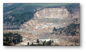
The horrific mudslide and loss of life in Snohomish County on March 22nd is an ongoing tragedy in Washington State. Six days after the disaster, 16 people are known dead and 90 are still missing. A debate rages about Steelhead Drive near Oso, Washington. This was a known slide area, geologically unstable. Search and rescue workers will be hard at work for some weeks digging through the mud and debris scattered across one square mile up to 30 feet deep.
Why were building permits issued for this area? Should the County government have purchased these homes to get the residents out of harm’s way, as King County apparently did in Maple Valley? Was the Washington National Guard activated quickly enough? These questions are unanswerable at this time.
One fact is certain: future disasters such as the Oso Slide will occur. They might be slides, or bridge collapses or floods. They could be much larger in scope: an earthquake, lahar, tornado or terrorist event.
We live in an age of the Internet and smartphones and ubiquitous technology. There are apps and technologies which can help responders to disasters such as the Oso Slide. What are they, and how can we apply them.
Mapping
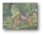
Oso Slide Map
Most people understand maps. Maps help us intuitively understand our place in the world and even our location on our block. Maps on our smartphones guide us easily to unknown addresses and give us warning of traffic problems on the route.
The Oso Slide and similar disaster scenes present a new problem: the third dimension: height (or now, depth). We know the two dimensional map of the Oso: outlines of properties and the Stillaguamish river and Highway 530. And we know a vast volume of mud now covers that area. But in pursuing rescue efforts, how deep is the mud in any particular area? Where should searchers concentrate their efforts?
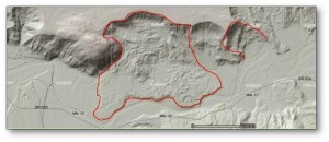
LIDAR of Oso Slide
Ideally, we’d have 3-dimensional maps of all such geographic areas prior to a slide, and we’d be able to quickly produce 3-dimensional maps after a slide or lahar. Such maps would show the depth and extent of the mud throughout the disaster area. Such maps can be produced by technologies such as LIDAR and pictometry.
Common Operating Picture
Common Operating Picture or COP is an extension of mapping. COP maps show everyone involved in responding to the disaster – but especially the incident commanders – an up-to-the-minute view of the scene. COP software will show the location of each individual responder, the location of all equipment on the scene, markers for human remains discovered and all other significant debris. The COP software allows the incident commander to properly direct new resources – vehicles, equipment and people – to exactly where they are needed on-scene. And COP software protects the responders by accounting for them every minute they are in the disaster area.
Just as importantly, COP will produce a history of the disaster as rescue unfolds. It will show areas which have been physically surveyed, where remains were uncovered and how the rescue proceeded. This is vital so that responders can learn about the incident and train to better handle the next one.

Seahawks Victory Parade (Reuters)
COP is vital not just in mudslides, but in just about any incident, whether it be for deploying police and emergency medical teams during the Seahawks victory parade, protecting fans at a Mariners’ baseball game, managing a major fire or responding to a terrorist event. COP is the incident commanders’ best friend when it comes to managing all the responders and equipment on-scene.
As one example, the Seattle Police Department leads an effort to deploy COP software from a company called 4QTRS for emergency and incident management. COP software should be deployed and used by every emergency response agency in the nation.
GPS and cell phones
Most of us know our smart phones contain global positioning software (GPS). GPS allows us to tweet and use Foursquare and to post photographs to Facebook which automagically contain the location of the photograph. Many of us use apps like “Find my iPhone” which depend upon GPS.
From an emergency response viewpoint, when you call 911 from a mobile phone the GPS in the phone or (if it has no GPS), the location of the phone as triangulated between nearby cell phone towers allows responders to find you, even if you can’t tell them exactly where you are.
Beyond mobile phones, a number of companies are starting to develop and produce small devices which can be attached to keys or pets or even to kids (in their clothes or backpacks, not in their bodies!) to quickly locate lost keys or wallets. PebbleBee is one such device under development by two Boeing engineers in their spare time.
There are many applications of GPS in search-and-rescue.
In the case of the Oso slide, emergency services and wireless companies could find every signal which was active in the area based on records from nearby towers. Those signals link back to a wireless phone number and account. This gives responders some idea of which people (or at least which people’s mobile phones) were in the area prior to the slide. It is doubtful the cell phone signal would travel through many feet of mud, but it is still possible that, even after the slide ended, telecommunications company records might show which cell phones were active and give some idea of where the phones were located.
In many other kinds of disasters, such information might be crucial. During floods, major snowstorms, tornadoes and hurricanes, having an accurate fix on all the mobile phones in the disaster area, both before and after the event, would be critical to finding and rescuing the injured.
Yes, tracking the locations of individual people is very much like living in a surveillance state. But if you are buried in a collapsed house it could mean the difference between life and death. Your family’s life.
License Plate Recognition and Traffic Video Cameras
Video cameras are ubiquitous on streets and highways nationwide. Seattle Police collected over 7 million plate numbers and locations using license plate recognition (LPR) software in 2012.
Perhaps every traffic camera in the state should be equipped with digital recording software to record the vehicles and license plates passing down state highways. In the case of the Oso Slide, emergency managers could quickly determine which vehicles entered the Steelhead Drive area but did not leave, giving good evidence of who might be trapped in the slide.
Again, such video tracking and license plate recognition raises grave concerns about privacy. Polices and laws may need to be crafted to keep the data restricted, perhaps just in the hands of transportation departments unless allowed for police or responder use in an emergency. The digital records should be destroyed after some short period of time, e.g. 30 days.
School Emergencies and Building Diagrams
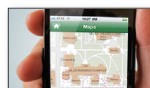
A Potential Campus Diagram App
School shootings and other incidents of domestic terrorism involving schools, shopping malls and elected officials are all too common. Anyone can name a dozen or such incidents such as the Tacoma Mall shooting from a few years ago, Gabby Giffords’ shooting, Columbine, LAX airport, the Washington Navy Yard and the terrible massacre at Sandy Hook.
Can apps and technology help with the response to such events?
Prepared Response is a firm in Kirkland which specializes in digitizing school building and campus diagrams, shopping mall diagrams and similar small-scale maps. They’ve developed software called Rapid Responder. Using this app officials can note the locations of exits, hazardous materials, utility shut-offs, evacuation plans, shelter-in-place locations and much more. The app and diagram can be used by agencies responding to a school or mall emergency to properly deploy officers and quickly enter the building. There is the potential for such an app to be connected to the video cameras inside the schools or malls, so the responders could actually see, real-time, what’s happening in the building.
Other Applications
Alex Petit is the former Chief Information Officer for the State of Oklahoma. John Letchford is the former CIO for Massachusetts. Both these CIOs deployed technology to support disasters such as the Moore, Oklahoma, tornado and the Boston Marathon bombing. Here is a smattering of the apps they quickly deployed, “on the fly”, after the disaster:
- A Pinterest-based app to take photos of prized possessions found in the debris field in the wake of the Moore tornado. In many cases such possessions were intact but had been carried hundreds of feet or miles from the original home. The Pinterest app “Owner Connect” allowed people to post photos of the items found on their property so their neighbors could identify and reclaim them.
- The Oklahoma Agriculture Department produced an app called “Pet Connect” to do a similar function for lost pets – allow the finders to post photos of the pets so the owners could reclaim them.
- Donations. After any disaster, people across the nation are extraordinarily generous with donating food, water, blood, clothing and other material. The “donor connect” app operated like a bridal registry after the Moore tornado, allowing the Red Cross and others to quickly link the needs for certain items to those which had been donated.
- Storm shelters. Some homes in Moore had storm shelters and families went into those shelters before the tornado struck. But there was so much debris that some of the shelters were jammed shut with debris. Creating a map of known storm shelters is a potential future app for tornado-and-hurricane-prone areas of the country.
FirstNet
FirstNet
Many of the applications described above require a robust wireless network in order to properly work. But, after some disasters, many cell sites may be destroyed or run out of power and go off the air. Hurricane Katrina was possibly the worst example of such lack of wireless networking, but similar problems occurred after Superstorm Sandy and other disasters.
Recognizing this problem, Congress, in 2012, created the First Responder Network Authority and funded it to build a nationwide 4G wireless network for use by responders to both daily incidents and major disasters. FirstNet is now in the planning stage, but promises to give responders the network they need to support this wide variety of apps which can speed rescue after incidents.
Will we be ready for the Next One?
Nothing will ease the pain of the survivors and relatives of the Oso Slide. No technology can produce a time machine to go back and evacuate 100 people from Steelhead Drive in the early morning hours of Saturday, March 22nd. But we can learn from this disaster. We can apply existing technology and develop new apps to speed and improve our response to such disasters in the future. Because these disasters will occur again. And we need to be better prepared.


